In recognition of their ability to protect and maintain high water quality, the riparian areas and wetlands of Idaho's forested watersheds have earned special protection in the IFPA rules, called Stream Protection Zones (SPZs). Learn how to correctly locate and mark SPZs.
In recognition of their ability to protect and maintain high water quality, the riparian areas and wetlands of Idaho’s forested watersheds have earned special protection in the IFPA Rules, called Stream Protection Zones (SPZs).
Perennial streams are usually easy to locate, but intermittent and ephemeral streams and their SPZs can be more difficult to identify, especially during dry periods. To ensure that equipment operators are clear about protection boundaries, SPZs should be clearly marked at frequent intervals with plastic flagging, paint, or signs.
Work with your local IDL Forest Practices Advisor if at all uncertain about where SPZ boundaries should be.
Definitions
Stream: A natural water course of perceptible extent with definite beds and banks which confines and conducts continuously or intermittently flowing water. Definite beds are defined as having a sandy or rocky bottom which results from the scouring action of water flow. Any reference in these rules to Class I streams shall also apply to lakes.
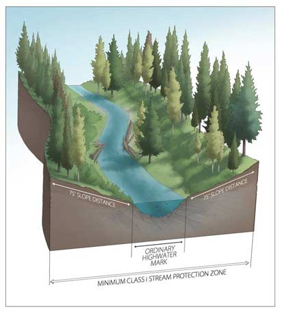
Class I streams are used for domestic water supply or are important for the spawning, rearing or migration of fish. Such waters shall be considered Class I upstream from the point of domestic diversion for a minimum of one thousand three hundred and twenty (1,320) feet.
Class II streams are usually headwater streams or minor drainages that are used by only a few, if any, fish for spawning or rearing. Where fish use is unknown, consider streams as Class II where the total upstream watershed is less than two hundred and forty (240) acres in the north forest region and four hundred and sixty (460) acres in the south forest region. Their principle value lies in their influence on water quality or quantity downstream in Class I streams.
Class I Stream Protection Zone: The area encompassed by a slop distance of seventy-five (75) feet on each side of the ordinary high water marks.
Class II Stream Protection Zone: The area encompassed by a minimum slope distance of thirty (30) feet on each side of the ordinary high water marks. For Class II streams that do not contribute surface flow into Class I streams, provide soil stabilization and water filtering effects by leaving undisturbed soils in widths sufficient to prevent washing of sediment. In no case shall this width be less than five (5) feet slope distance on each side of the ordinary high water marks.
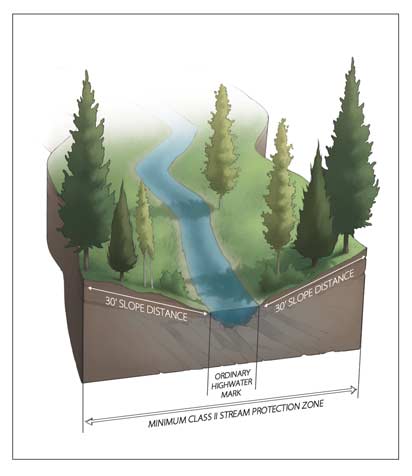
Ordinary High Water Mark: The mark on all water courses, which will be found by examining the beds and banks and ascertaining where the presence and action of waters are so common and usual, and so long continued in all ordinary years as to mark upon the soil a character distinct from that of the abutting upland, in respect to vegetation, as that condition exists on the effective date of this chapter, or as it may naturally change thereafter.
For more information about Stream Protection Zones, see
 Sign In


 Find a Service Provider
 Browse the Library
 Federal and State Programs
 Find Income Streams for Your Land
 Carbon Sequestration
 Conservation Tax Center
 Land and Energy Conservation Tools
 Sustainable Land Management
 Tree Farms
 Wetlands and Wildlife
 LandCAN Sites
 Alabama LandCAN
 Arkansas LandCAN
 California LandCAN
 Colorado LandCAN
 Georgia LandCAN
 Idaho LandCAN
 Louisiana LandCAN
 Maine LandCAN
 Mississippi LandCAN
 Texas LandCAN
 Virginia LandCAN
 HabitatCAN
 About LandCAN
 Get To Know LandCAN
 LandCAN Blog
 LandCAN Success Stories
 Earthx Conservation Sessions
 Donate
 Create an Account
 Advertise with LandCAN