Landscape Scale Conservation in the North Woods
By: Amos S. Eno
Posted on:09/23/2010 Updated:09/24/2010Ten years ago a conservation easement on three-quarters of a million acres of land was unheard of. The Pingree Partnership changed all that.
2011 will mark the 1 0-year anniversary of the Pingree Forest Partnership’s easement. Well-known to many, at least in the northeastern part of the country, its superlatives still bear recounting:
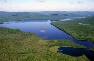
At 762,192 acres, the Pingree Forest conservation easement is still the largest ever recorded in the country.
- The easement language pioneered the concept of conservation in its truest sense: keeping the land as it has been for more than a century, as a well-managed forest, profitable for timber production.
- The working forest easement conditions allowed pricing the easement at full market value, which was quite affordable by the standards of most conservation easements at the time.
- The partners developed a completely new and innovative method for monitoring the landscape scale easement.
- The project conserved the largest parcel in the northern hemisphere ever to have received certification by the Forest Stewardship Council.
- For the first time, a small amount of public funding was spent to protect a private working forest.
I personally believe one of the other standouts of the Pingree Forest Partnership is that the Pingree family had a long tradition of outstanding land management. For seven generations, including the time at the turn of the century when much of New England’s timber stands were depleted - they have been providing not only timber but wildlife, habitat, and recreational opportunities for people. My participation in helping to fundraise $7 of the $28 million required for the project is among the achievements of which I am most proud, and I count myself lucky to have been a part of it.
The Pingree project began as a discussion in 1996 among Pingree family members and the
New England Forestry Foundation or NEFF, in particular, a remarkable individual by the name of
Keith Ross, now a Senior Advisor at
LandVest. Ross, at the time, was a new hire at NEFF: a certified forester who also had the advantage of having worked for a number of conservation groups. Keith is the “eco-entrepreneur” who deserves full credit for the innovative nature of the Pingree easement.
The Easement Recipe for Success
Keith recentl

y told me that he felt the Pingree easement design was successful for three reasons:
- It is built around the short-term and long-term goals of the landowners.
- It provides flexibility, which is a requirement for adaptive management.
- Its restrictions can be cost effectively monitored.
Keith crafted the easement to support the landowner. He says, “you need to have the landowner and the easement holder philosophically aligned.” In this case, NEFF wanted to protect a healthy working forest. Keith’s focus was ensuring that a good management plan is in place and that it is sustainable but also flexible. “One aspect of sustainability is that over a 10-year period, on average, you should not cut more than you grow. In 40 years I’ve seen a lot of things change. You have to be adaptive to new information and advances in technology, and an easement needs to be adaptive to changes in forestry too.”
In developing an easement of such enormous size, Keith said, “I knew I’d really have to focus on it from a monitoring standpoint because that had always been the thing that held people back” from attempting such large easements. For example, “how do you monitor ‘no hunting’ or calculate ‘square feet of basal area’ for such a large easement?” You don’t.
The answer turned out to be a combination of satellite imagery and ground truthing. Steve Sader, a University of Maine professor has developed a process that utilizes several computer programs to compare successive satellite photos of the easement land to the timber company’s GIS mapping of the areas they work in each year. After the analysis, they conduct random and selective ground truthing, with each iteration fed back into the computer model to improve its accuracy.
As for the $28 million cost of the easement, Keith’s attitude was always “Never worry about the money; if you worry, you won’t do anything. The project will sell itself, if it’s good. Its economic and ecological analysis will help find the funders.”
Keith understood that in a family like the Pingree’s, land ownership is often held in trust, so family members legally cannot give anything away. They have a fiduciary obligation to provide for future generations. The parties negotiating the easement started from the premise that all landowners are entitled to fair market value for their property. Yet leaving the timber rights in family ownership had the effect of reducing the fair market easement price relative to many conservation projects where the property is purchased in fee.
The Pingree ExampleThe success of the Pingree Partnership reaches far beyond Maine. Keith says he knows of “millions of acres protected across the country now that are using the Pingree model. That includes a number of TNC, Conservation Fund and TPL projects with REITs (Real Estate Investment Trusts) in the South and West, as well as projects i

n the Great Lake states, and all over the Northeast. Pingree also “opened the door to public funding for this type of project,” although it was funded predominantly with private dollars.
In an age when untold millions of government and philanthropy dollars are spent studying how to conduct landscape scale conservation, the Pingree easement still stands as a shining example.
 Sign In
 Sign In
